| |
| |
| Coming Soon... |
|
|
 We are currently working on an interactive map guiding you around the village of Thornton-le-Moor. The map will focus on interesting buildings, features and history of the village. We are currently working on an interactive map guiding you around the village of Thornton-le-Moor. The map will focus on interesting buildings, features and history of the village.
While you are waiting ...
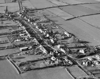
An aerial view of the main street of Thornton le Moor taken in 1983 reveals the layout of a typical medieval village. Long garths or tofts stretch out from back doors to adjoining fields; separated only by a back lane, the point at which the ploughs turned nine hundred years ago. To the north, the back lane was once the dividing line between the open fields owned by the lord of the manor and the smaller subsistence plots which his bondsmen, the villagers were allowed to farm. Serfdom existed here into the early fourteenth century.
Comparisons with the 1842 Tithe map (page 4) shows that the layout of the village has remained largely unaltered over the past hundred and fifty years although in the latter part of the Twentieth Century the village has spread along the main road. From the 1940Õs more modern houses have been added either side of Thiefhole Lane, gaps have been filled, notably west of The Black Swan and some properties replaced, but many of the terraced cottages and detached houses dating back to the seventeenth century remain. In 1801 there were forty-seven dwellings in the parish, by 1999 this had grown to one hundred and nineteen.
|
|
|
|
|
|
|